|
Tom Loffman's Sacramento Weather January 2010 Storm |
|---|
|
The ten days of rain has ended. Some additional rainfall is due on Friday and Saturday. The storm appears to
be a bit stronger than indicated yesterday, so we might get as much as .30" inch of rain in some locations. After that, the models
are beginning to agree on the pattern and timing for early February, and another week of rain is headed our way. Today, the models are
starting this new pattern on the 3rd, slightly ahead of yesterday's timing. Rain totals
could range from 3.50" - 5.00" in Sacramento, with several additional feet of snow in the Sierra.
The recent stormy period brought about four feet of snow to Blue Canyon. The primary weather reporting stations in California registered significant rain totals over this same period. Ukiah measured over 11" of rain. In the Bay Area, San Francisco had 5.37", Oakland 7.20" and San Jose 3.76". In Sacramento we averaged about 3.50" and some areas got over 4.00".Up the hill, Gold Run had over 9.00" and Foresthill over 7.00". Stockton and Modesto got about 2.50". Southern California rain totals were higher. Santa Barbara got 5.32". Burbank got 5.76". Los Angeles had a bit over 4.00". Long Beach measured 6.65", and San Diego had 3.30". As the current storm pattern has ended this will be my last update on this event. I will start a new page covering the next week of rain headed our way. Tom Loffman January 27, 2010 |
|
Here is what I wrote here on January 10th: "My analysis of the long range weather models indicates a very cold and wet storm pattern heading for Northern California starting about
January 16th or 17th and continuing for 9-10 days. This pattern has the potential to bring at least several inches of rain to our
area accompanied by strong winds and cold temperatures." The pattern of storms moved in and after almost five inches of rain in the Sacramento
area, we are looking for a break in this string of rainy days. Scattered showers should continue through today, then, I am expecting a break
that should last for a couple of days.
In the Sierra snow levels have been rising and it's now 37 degrees at Blue Canyon with rain. Snow has been falling at Truckee with a temperature of 32, and at Tahoe the snow and rain has stopped and it's 42. Our next chance of showers comes late Friday and early Saturday. Starting on February 3rd, we go back into a showery pattern, with a stronger storm and another possible week of rain starting on the 5th. Travel conditions are improving over Northern California, however, river levels continue to rise as our recent rainfall flows into our river systems. Tom Loffman January 26, 2010 |
|
The current storm is the last in a string of storms that began on Saturday evening, January 16th. Over the past 24 hours we have added .25" - .50"
of additional rainfall to our Sacramento area rain totals. The rain should continue, off and on, through early tomorrow, then taper off. A break
is expected after that with another chance of a few showers moving in on Saturday. The long-range computer models continue in some disagreement
on the weather patterns expected over the next couple of weeks. However, all are in agreement that a more significant rainy pattern will begin
again during the second week of February.
In the Sierra the snow level continues to rise. Blue Canyon is reporting heavy snow with a temperature of 33 degrees, Tahoe is reporting rain at 37 degrees, Donner Lake 36, Tahoe Donner 35, and Alpine Meadows 34. As warmer air moves in the snow level will continue to rise into tomorrow, and a mix of rain and snow may fall over Donner Summit, at 7200ft. If you are planning on a trip over either Donner or Echo Summit, you must be prepared for long travel times, and must have chains. The additional rainfall expected through tomorrow will continue to pour into our rivers and continued river level rises are expected over the next few days. If you have activities or interests on or near any of our rivers you must monitor river levels and conditions. Tom Loffman January 25, 2010 |
|
The last in a string of strong storms is now moving over California today and will be with us for the next couple of days. After mid-week
we will return to a pattern of higher pressure, and less frequent, weaker storms. Snow levels will be rising over the next couple of days
and may reach the level of Donner Summit by tomorrow. Temperatures in Sacramento will be warming a bit as well. After a low of 1 this morning,
the temperature at Truckee is now 32 with light snow. At Tahoe it fell to 4 this morning and is now 34 with light snow. If you are planning
on driving over the summit today or tomorrow make sure you have chains and are prepared for slow driving conditions.
The current storm could bring an additional 1.00"- 2.00" of rain to Sacramento over the next few days. This is the last in a series of strong storms that has been pounding the region for the past couple of weeks. The long-range computer models continue to indicate rainfall moving into our area after mid-week. However, these storms will be much weaker, and rainfall totals will be light. We should get a two day break starting Wednesday the 27th. A weak storm moves in on Friday and Saturday, a slight chance of rain on the 1st and 2nd of February, and another slightly stronger storm starting around February 5th. The additional rainfall expected over the next few days will add to our river levels that are expected to continue rising well after the storm has ended. If you have activities or interests on or near any of our rivers you must monitor river levels and conditions as the runoff from two weeks of storms flows into these river systems. Tom Loffman January 24, 2010 |
|
The break from a week of rain has arrived, although it is not a complete break. Scattered areas of showers continue over parts
of the state. Light
snow is still falling at Blue Canyon with temperatures a bit below freezing. The snow at Truckee and Tahoe has paused, although occasional
snow showers continue over higher elevations. One more sizeable storm is on the way, however. This time snow levels will be rising and
by Monday and Tuesday the snow level may be as high as 7000ft - just below the level of Donner Summit.
The next storm moving our way looks impressive on satellite photos, and is expected to bring at least another inch of rain to the Sacramento region. It should begin tomorrow (Sunday) and last a couple of days. The next storm after that is due about Friday, the 29th, and beyond that more storms will be moving toward the West Coast. Another moderately strong one is possible Feb. 3rd-5th. There is no indication yet that we will be in an extended period of high pressure over the next couple of weeks. However, the storms indicated for February appear to be normal for this time of year, and I am not expecting a repeat of this weeks constant wind and rain. Since the 16th I have measured 3.37" or rain, and the airport locations between 2.75" - 3.75". My original post here, on January 10th, said, "This pattern has the potential to bring at least several inches of rain to our area...", so things have been working out about as I expected. Some areas of Northern California have received substantially more rain than Sacramento, and this water continues to move into valley river systems. If you have interests or activities along or near any of our rivers, river levels and conditions should be monitored carefully over the next week. These rivers will continue to rise well after the rain has stopped as it takes a number of days for the water to flow through the system. Tom Loffman January 23, 2010 |
|
The rain continues today (Friday) although the intensity has eased up. The wind has picked
up a bit and barometers are rising, after breaking all-time low records over the past couple of days. In the Sierra snow continues to fall. Temperatures have cooled and the snow level is now a bit below 3,500ft. Temperatures at Blue Canyon, Truckee and Tahoe are in the upper 20's. The rate of snowfall in the mountains has slowed, and in some areas it has stopped. If you are planning on traveling over the Sierra passes you have a window of opportunity here. I am expecting overnight temperatures in the Sacramento area to fall into the 30's this weekend. However, I am not expecting a freeze. All-time record low barometer readings were registered up and down the Pacific Coast over the past couple of days. Records were set at Medford (28.88"), Eureka (28.90"), Reno (28.92"), parts of the Bay Area (28.85" at San Jose), Fresno (28.94"), Bakersfield (28.94"), Los Angeles (29.07"), San Diego (29.15") and Las Vegas (29.03). Did Sacramento set a new record? The old record was 980.4 millibars, or 28.95". Yesterday, our pressure fell to 980.2 millibars, still 28.95". Based on the millibar reading, we broke the record. Based on inches, we tied the record. Unofficial barometer readings in the area consistently fell to below 28.95", so we can say that this was a record event. After this weekend a new series of storms will be moving toward the West Coast. However, these storms will be warmer, and snow levels will be on the rise in the Sierra. The first one, due later on Sunday and lasting into Tuesday, could bring another 1.25"-2,00" of rain to Sacramento. After that storm, another one is due to move in on Friday and over next weekend. This storm should bring an additional .50" to 1.00" of rain. The long-range computer models disagree on the strength of storms after next weekend. One model indicates fair weather for early February. Other models show some rainfall continuing, but amounts would be light. The recent rainfall continues to pour into valley river systems and if you have interests or activities along or near any of our rivers, river levels and conditions should be monitored carefully. Rivers will continue to rise well after the rain has stopped as it takes a number of days for the water to flow through the system. Tom Loffman January 22, 2010 |
|
After a break in the rain, another, in our long string of storms, is bringing additional rainfall to
Sacramento and snow to the Sierra. Fortunately, the wind has dropped off, as has the barometric pressure. As I write this all-time
records for low pressure are falling all over the state. The long-range computer models continue to say that more storms
are on the way. However, the models disagree, as usual, on the timing and intensity of these storms. Temperatures in the Sierra are falling and its now in the mid-20's with snow falling at Truckee and Tahoe, and 30 with snow at Blue Canyon. Snow levels are below 5,000ft and should fall to below 4,000ft as the coldest air of this current series of storms continues to move in. We will have a brief break in the rain over the weekend. However, the break won't last long before the next storm moves in. Overnight lows in Sacramento will drop into the 30's on Saturday and Sunday morning. I am not expecting a freeze with this cold air. Barometers all over the state are now recording record low readings, and pressures continue to drop, as the center of this deep low pressure area moves directly over Northern California. I first mentioned this on the 15th, and this deep low had now arrived. My home barometer is currently reading 28.92" and is still falling. The all-time record for Sacramento was set on January 27th, 1916 at 28.95". Monterey is reading 28.86" and falling. I will have a records update tomorrow. However, when an all-time record falls this is certainly unusual. Two additional storms, one on the 25th and 26th and another one on the 29th, could bring an additional 2.00"-3,00" of rain to Sacramento. These storms will be warmer and snow levels will rise next week. The different long-range computer models have major differences for the period after January 29th. One model basically has just a few showers in the forecast after that. Other models continue to bring in rain, although the intensity of any storms after the 29th should be weak. As the rain is not yet over, and snow continues in the Sierra, travel continues to be slow and difficult over the mountains. Local rivers are still rising, and the ground is saturated. Additional rainfall may bring local stream flooding. If you are planning on traveling in the near future you should give yourself extra time, and be prepared for local road closures and delays. Tom Loffman January 21, 2010 |
|
Another wet and windy storm pounded our area overnight and this morning. As I write this we are in a brief
break. However, more rain and wind is on the way. Over the next couple of weeks Sacramento could receive another 4.00"-7.00"
of rain. Winds in the Sacramento region gusted today to over 50mph. Barometric pressure continues to plunge
and a near all-time record low pressure event may occur tomorrow. Over the past few days most Sacramento locations have received 1.50-2.00" of rainfall. An additional inch fell a week ago, so for the 7 day period we have received a bit over 2.50". Snow continues in the Sierra with temperatures at Blue Canyon, Truckee and Tahoe hovering around 32 degrees. The coldest temperatures during this period will occur on Friday and Saturday with snow levels falling to or below 4,000ft. Extremely low surface barometric pressure is still expected in the next 36 hours with the deepest low pressure of the current series moving over us at that time. Many Northern California barometers will fall to below 29.00" of mercury, and some all time records may be broken. Other than rain and wind, you should not expect anything unusual when this low pressure arrives. The record low pressure at Eureka is 28.91", San Francisco is 28.85", Sacramento 28.95" and for all of California 28.81". Most of these records were set on January 27, 1916. As I write this the pressure at Crescent City is 28.90" and falling. I have been expecting a break in the storms on Saturday (23rd). The computer models continue to disagree on the duration of this break. It may only last a day before the next storm arrives. Another brief break is possible around the 27th and again around February 1st. Timing these storms and breaks is difficult and so confidence in the timing is low. If you are planning on doing any traveling over the next several days you need to be prepared for difficult travel conditions, particularly over the Sierra. There may be road closures at times in the mountains, and travel times will be extremely long. Also, as the rain continues in our area, there may be some local flooding. River levels on both the Sacramento and American will be rising as runoff from this rainfall moves into our river system and flows toward the Bay and Delta. Tom Loffman January 20, 2010 |
|
The rain continues and more is on the way. Winds have been strong again this morning with gusts over 40mph.
Temperatures have cooled a bit in Sacramento and snow continues to fall in the Sierra above about 5,000ft. Temperatures at Blue
Canyon, Truckee and Tahoe are still at or slightly above 32 degrees. The latest satellite photos indicate additional storms on the
way. The coldest temperatures during this period will occur this Friday and Saturday. Snow levels should fall to or below 4,000ft in the Sierra. Extremely low surface barometric pressure is still expected on Thursday with the deepest low pressure of the current series moving over us at that time. Northern California barometers may fall to below 29.00" of mercury, and some all time records may be broken. Other than rain and wind, you should not expect anything unusual when this low pressure arrives. All long-range computer models forecast a break in the rain over the weekend. The length of this break is not clear - either a day or two, but definitely some relief from the pounding storms. After the weekend, there continues to be disagreement in the models on the next wave of storms heading our way. The models bring in a small storm on the 25th, and 28th. After that, they are in disagreement. It will be a few days before the situation becomes clear, so I will continue to say that there is a chance of more rain during the next couple of weeks, but with breaks at times. Because of the disagreement on the next round of storms to move toward California after this weekend, the long-range rain forecast ranges from about 2.00" to as high as 5.50" from the 20th through February 3rd. If you are planning on doing any traveling over the next several days you need to be prepared for difficult travel conditions, particularly over the Sierra. There may be road closures at times in the mountains, and travel times will be extremely long. Also, as the rain continues in our area, there may be some local flooding. River levels on both the Sacramento and American will be rising as runoff from this rainfall moves into our river system and flows toward the Bay and Delta. Tom Loffman January 19, 2010 |
|
The rain continues over Northern California, and this morning we had wind gusts as high as 40-45mph. Snow
has been falling in the Sierra, and at Blue Canyon there has been some rain, freezing rain, and snow, with temperatures just
above freezing. Snow has been falling at Truckee and Lake Tahoe with temperatures there at 32-24 degrees.
Snow levels continue to range between 4800-5800ft. I am expecting periods of rain over the next few
days with snow in the mountains and gradually falling temperatures and snow levels. There will be breaks at times, and as
I write this the rain has stopped, and the sun is shining through breaks in the clouds. The long-range computer models continue to be in some disagreement as to the timing of the next extended break in this pattern. This morning the models wanted to end the rain late Friday, and bring us some relief over the weekend. The timing of the next series of storms after that is not consistent as I look at successive computer model forecasts, so I will continue to be cautious about the timing of any breaks in the storm pattern. The coldest temperatures will occur on Thursday and Friday. Snow levels should fall to, or below, 4,000ft in the Sierra. Upper level temperatures are going to be quite cold, and normally this would indicate snow to very low elevations. However, some warm, moist air will be moving in at the surface and this will prevent the depth of cold that we experienced in December. As I have been discussing in these updates, surface pressure will fall to near record levels on Thursday, as a deep low pressure system moves over Northern California. This pressure might be at or below record levels in some locations. The previous record lows were set on January 27, 1916. Nothing unusual is expected with this low pressure other than the last rain and wind event of this week. Over the next couple of weeks we can expect another 4.50" to 8.00" of rain in the Sacramento area, with heavier amounts in the northern valley, the Coast Range, and the Sierra Foothills. Already, rain totals in some locations east of the valley are nearing 4.00" to 5.00". If you are planning on doing any traveling over the next several days you need to be prepared for difficult travel conditions, particularly over the Sierra. There may be road closures at times in the mountains, and travel times will be extremely long. Also, as the rain continues in our area, there may be some local flooding. River levels on both the Sacramento and American will be rising as runoff from this rainfall moves into our river system and flows toward the Bay and Delta. Tom Loffman January 18, 2010 |
|
Showers began last night (Saturday) at about 9:30pm, and today (Sunday) has been a day of steady rainfall
over our area. Much more rain is on the way. There should be a break in the series of storms on or near next weekend (23rd). After that,
more storms will bring a new round of rain to California. This morning, the overnight computer models indicated a long break between
storms. However, the newest models do not support much more than a brief pause in the precipitation. Temperatures will fall slowly over the next few days and snow levels in the Sierra should drop to near or a bit below 4000 feet by Friday. Barometers will fall gradually and reach a very low reading on Thursday. Computer models continue to show a low pressure of near 980-982 millibars at that time, which would be a bit below 29.00" of mercury. This is close to the all time low pressure record for Sacramento and some Northern California locations could tie or break their all time pressure records set in January of 1916. Nothing unusual is expected with this low pressure other than rain and some wind. Once the second series of storms arrives, around the 28th-29th, rainfall rates may again get heavy. Total rain accumulation over the next couple of weeks should range from 6.50" to over 10 inches. More than 10 inches of may may fall in parts of Northern California, particularly in the north end of the Valley, the Coast Range, and the Sierra Foothills. It is possible that over 10 feet of snow may fall at higher elevations of the Sierra. If you are planning on traveling to the mountains it is essential that you be prepared for difficult travel conditions, and have survival supplies in your car. The most difficult conditions will occur Tuesday through Friday. Tom Loffman January 17, 2010 |
|
Note totals approaching 10 inches in the Coast Range and Sierra 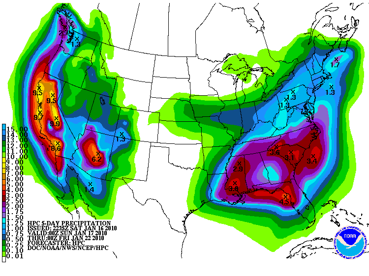
|
|
We are enjoying our last day of peaceful weather before the rain begins. The first drops are expected overnight or
early tomorrow (Sunday). Once the rain starts it should be with us for the better part of the next two weeks. All computer models are
forecasting substantial rain totals over that period of time. The range of rain total forecasts is from 6.40"-9.45". This could bring
up to 10 feet of snow to parts of the Sierra, and the possibility of even greater amounts to higher elevations. Needless to say,
travel may become extremely difficult, or impossible, at times in the mountains. The coldest days are expected to be Thursday, Jan. 21st through Sunday the 23rd. Snow levels should drop to or below 4,000 feet at that time. Yesterday, the computer models indicated a break in the rain on the 23rd and 24th. However, today, the models bring in the next storm more rapidly, and we may not get much of a break next weekend, if any. Today's models bring in the break on the 27th and 28th. I have been saying here that with a storm pattern like this, the timing of any breaks is extremely difficult. The models continue to indicate a very low barometric pressure for Thursday, Jan. 21st. A couple of days ago the pressure was forecast to fall to 980 millibars, or a bit under 29.00 of mercury. The latest models lower the pressure on Thursday to 988 millibars, or 29.17". This is not a record, but is still a very low pressure reading. It should be raining and windy at that time, but nothing unusual is expected with this low barometer, other than we are not used to seeing it that low. After the 23rd, temperatures should begin to rise a bit and that means slightly higher snow levels in the mountains. Rain totals after next weekend are not expected to be as great as what we will receive over the next week. If you have travel plans, or any other plans or interests that might be effected by heavy rain and snow, you need to plan accordingly. It is possible that there might be some low elevation flooding during the 18th-22nd, and snow accumulation in the Sierra might cause local road closures at times.
Tom Loffman |
|
My analysis of the upcoming storm pattern is essentially unchanged from yesterday, except for a few minor
adjustments to the rain totals. We are currently in a nice break between storms, with the next storm expected to begin over
the weekend. I am looking for a very wet
two weeks ahead and travel may become difficult at times, particularly in the Sierra. There is a slight chance of rain tomorrow, Jan. 16th, with snow in the Sierra. Rain will increase on Sunday (17th) and will continue, off and on, through Friday (22nd). By the 22nd we could have a one week total of 3.00"-6.00" of rainfall in the valley, with many feet of snow in the Sierra. Mountain travel may become extremely difficult at times. Temperatures will gradually cool through the week and snow levels could reach 4,000ft or less by Friday. The computer models continue to forecast a very low barometer reading for Thursday, Jan. 21st. Over the past few computer model runs this is indicated to be as low as 980 millibars here, which computes to 28.93" of mercury. The all time low pressure record for Sacramento is 28.95" and occurred on January 27, 1916. On that date record low barometers were noted in most Northern California locations. I will be monitoring the pressure as this series of storms moves in and will report any records that are recorded. The coldest temperatures will occur from the 21st to the 23rd. I am not expecting the intense cold that we experienced in December, however. After next weekend, the following series of storms should be a bit warmer and snow levels will rise. Rain amounts over the next couple of weeks could total from 6.00" to 9.00" in the valley, with much higher totals in the Coast Range and Sierra foothills. It is possible that more than 10 feet of snow will fall at some higher elevation mountain locations, and this should be great news for skiers. The best chance for a break in the rain will be on Saturday the 23rd, and possibly last through the 24th. However, with a series of storms lined up across the Pacific the exact timing of each storm is uncertain and the timing of any breaks is difficult. If you have travel plans, or any other plans or interests that might be effected by heavy rain and snow, you should begin to plan accordingly. It is possible that there might be some low elevation flooding during the 18th-22nd, and snow accumulation in the Sierra might cause local road closures at times.
Tom Loffman |
|
We are now in a nice break between storms, and the next round of storms is on the way. I am expecting a very wet
two weeks ahead and travel may become difficult at times, particularly in the Sierra. There is a slight chance of rain on Saturday, Jan. 16th, with snow in the Sierra. Rain will increase on Sunday (17th) and will continue, off and on, through Friday (22nd). By the 22nd we could get 3.00"-6.00" of total rainfall in the valley, with many feet of snow in the Sierra. Mountain travel may become extremely difficult at times. Temperatures will gradually cool through the week and snow levels could reach 4,000ft or less by Friday. The coldest temperatures will occur from the 21st to the 23rd. I am not expecting the intense cold that we experienced in December, however. After next weekend, the following series of storms should be a bit warmer and snow levels will rise. Rain totals over the next couple of weeks could total from 4.00" to 8.50" in the valley, with much higher totals in the Coast Range and Sierra foothills. It is possible that more than 10 feet of snow will fall at some higher elevation mountain locations, and this should be great news for skiers. The best chance for a break in the rain will be on Saturday the 23rd. However, with a series of storms lined up across the Pacific the exact timing of each storm is uncertain and the timing of any breaks is difficult. If you have travel plans, or any other plans or interests that might be effected by heavy rain and snow, you should begin to plan accordingly. It is possible that there might be some low elevation flooding during the 18th-22nd, and snow accumulation in the Sierra might cause local road closures at times.
Tom Loffman |
|
The rain over the past two days was welcome, and added about an inch to our seasonal rain total. However,
a much more significant series of storms is on the way. Rain should begin again on Saturday, Jan. 16th, with snow in the Sierra. Initially, snow levels are not expected to be particularly low. However, if you are planning on traveling to the mountains this weekend you must be prepared for this snow. Rain and snow will continue next week with heavier amounts Monday through Thursday. At that time temperatures will fall, and rain totals for the four day period could add up to 4.00" inches around Sacramento and at least several feet of snow in the Sierra. Travel will become extremely difficult at times in the mountains. The coldest temperatures and lowest snow levels will occur next Friday, Saturday and Sunday. The long range computer models do not indicate the intensity of cold air that we experienced in December, so I am not expecting extremely low snow levels at this time. However, snow may fall as low as 3,000ft by Saturday, Jan. 23rd. Rain totals for the 10-12 day period may reach 5.00'-7.00' for the Sacramento metro area. Today's computer models show a couple of breaks in the pattern with possible partly cloudy skies here on Saturday the 23rd, and again on the 25th and 26th. As I am looking almost two weeks ahead the confidence in calling these breaks in the storm pattern is not high at this point. As I have been advising here, if you have travel plans, or any other plans or interests that might be effected by heavy rain and snow, you should begin to plan accordingly. It is possible that there might be some low elevation flooding during the 19th-22nd, and snow accumulation in the Sierra might cause local road closures at times. Tom Loffman January 13, 2010 |
|
Today's rainfall and the rain tomorrow is the beginning of a new weather pattern for us.
The large upper air ridge of high pressure that has dominated our weather in recent weeks is breaking down. However,
a much more significant storm pattern is on the way. Starting this weekend, a second round of storms moves in. This morning's computer models indicate a slight change of showers on the 16th, with rain more likely beginning on the 17th. The rain should last until at least the 27th with a possible break after that time. However, the timing of the break now seems uncertain, as another strong storm is now due to move in on the 25th and could last for a few days. This second storm appears to be a substantial rain producer and could bring heavy rainfall to an area that will already be feeling the effects of a number of days of at least moderate rainfall. Temperatures will be coldest and snow levels lowest during the 21st to 24th time period. Snow levels in the Sierra should fall to below 4,000' by the 22nd and will remain low for several days, with the potential for large amounts of snow accumulation at that time. The coldest temperatures should occur on the 23rd. Rainfall totals for the Valley over this 10 day time span could be substantial and, depending on the computer models, could range from 4.50 inches to over 10.00 inches in some locations. As I am looking out almost two weeks ahead, these totals may not develop. However, if you have any concerns about possible effects from such rain accumulations, or have travel or other plans for this time period, you need to begin to plan for heavy rainfall moving in. Tom Loffman January 12, 2010 |
|
The storm forecast for Tuesday the 12th and Wednesday the 13th is the beginning of a new weather pattern for us.
The large upper air ridge of high pressure is breaking down and this first storm will bring the most rain to the area since December
12th-13th. We may get up to an inch of rain from this one. Then, starting on the weekend, a second round of storms moves in. The morning computer models indicate a slight change of showers on the 16th, with rain more likely beginning on the 17th. Days with significant rainfall are 19th-20th, 22nd, and 25th. The last day of rain is now the 26th with clearing and north winds developing on the 27th. The temperatures indicated for this period appear to be warmer than forecast yesterday. However, the storm still has the potential to create significant travel problems in the Sierra. Tom Loffman January 11, 2010 |
|
My analysis of the long range weather models indicates a very cold and wet storm pattern heading for Northern California starting about
January 16th or 17th and continuing for 9-10 days. This pattern has the potential to bring at least several inches of rain to our
area accompanied by strong winds and cold temperatures. Snow levels could be very low and travel, particularly in the Sierra, may become difficult
if this pattern develops as forecast. I will update this commentary to keep you informed of my analysis of this event. Tom Loffman January 10, 2010 |