|
Tom Loffman's Sacramento Weather Sacramento Snow |
|---|
|
Snow in Sacramento? It happens occasionally, usually a dusting of a few flakes here and there, and for an hour or two. It
generally melts as it hits the ground. Measurable snow in our city is an extreme rarity. The possibility of snow occurs almost every winter,
but actual, measurable snowfall in Sacramento occurs seldom. The last flakes seen here were on January 28, 2002. They didn't last long,
melted as they hit the ground, but were fun while they lasted.
Why is it so hard for snow to fall in Sacramento? In order to get snow anywhere the temperatures has to be close to freezing and there has to be sufficient moisture in the air for snowflakes to form and fall to the ground. Sacramento is far enough south so that this combination rarely happens. If cold air moves in from the Pacific, the temperature of the ocean water warms the air above freezing and we get rain. If cold air tries to move in from the north or east it is usually very dry and the wind pushes Pacific moisture back out to sea. In the Midwest and East the geography allows the cold air sweeping in from the north, to interact with moisture coming up from the south or southwest and snowfall is much more common. In December of 1972 we had a period of about two weeks of very cold weather, and there were little spurts of moisture that moved into the airmass. This gave us a dusting of snow here and there. On February 5th of 1976 a very cold "upper level" low backed up ("retrograded") into Northern California and we had a day of widespread snowfall to sea-level. Temperatures hovered just above freezing for most of the day. Generous snow fell in the mountains, over the Coast Range, and even San Francisco's hills were blanketed in a mantle of rare, white snow. It was a day to remember. On that rare day snow fell in Sacramento, and 2" was recorded "officially" at Executive Airport. In March of 1942 a snowstorm blanketed downtown Sacramento with memorable snow, and the grounds of the Capitol became a winter wonderland, and the streets a nightmare for cars. The record Sacramento snowfall came in January of 1888 when 3 1/2" piled up over a couple of days. Measurable snow has been recorded here 14 times since records have been taken. It should be noted that the "Weather Bureau" was first established in the early 1870's, and weather measurements have been taken here since about 1850. In recent decades Sacramento has grown into a large urban area, and this has created what is known as an "Urban Heat Island". Our own experiences, and actual temperature measurements, tell us that at night, when the wind is light, it's much chillier in the countryside than in the city. Concrete and asphalt have replaced trees, ponds, and grass and this has resulted in a warmer, tougher environment for snow to fall and stick in Sacramento. What once was the country is now a shopping mall with a huge parking lot. It's no wonder that snow is more rare now than in the last century. Here is a link to the latest National Weather Service snowfall history for Sacramento: Sacramento Snowfall Chart The latest weather maps and computer model runs indicate the possibility of Sacramento snow from the next storm moving into our area. I will be tracking that storm here for you. Let's see what happens! Tom Loffman, Meteorologist December 6th, 2009 |
The GFS computer model verified perfectly and the low temperature fell to 34-35 degrees in most locations. So, it was about a degree or two too warm for anything but a few snow flurries in Sacramento. However, snow fell in the foothills. Rain mixed with snow was reported briefly at Mather Field and also at Stockton. The Bee reported that there were snow flurries in Arden Arcade and also some snow on the ground in Roseville, Granite Bay, Elk Grove, Galt, and Stockton.
There are various computer models that are used to generate a forecast and it appears as if the Winter Storm Warning was issued off the NWS Digital Forecast Database product. However, the GFS model was perfect and consistently called for temperatures above freezing during the rain event. It should be noted that during a cold rain event, snow mixed with rain is often reported at temperatures below 35 degrees, but usually doesn't begin to stick on the ground until the temperature reaches about 33 degrees.
It should also be noted that precipitation itself generates heat. Just as evaporation cools, condensation warms and releases heat, so this additional "latent heat" may have contributed to keeping us above freezing this morning.
December 7, 2009, 1pm
Here is the upper level (500mb) chart for this morning at 4am (12z). This shows the typical pattern for cold and snow in Northern California. The temperature at 500mb over Sacramento this morning was -29c. My research indicates that for snow to fall here the 500mb temperature must be colder than -30c, so it was not quite cold enough for snow to sea-level:
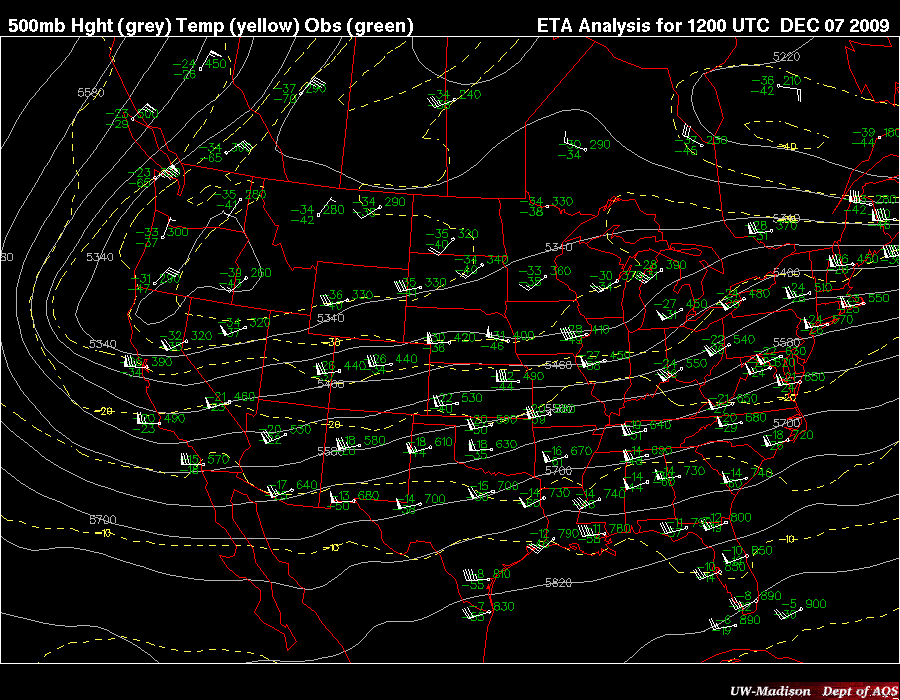
500mb 12z Monday 7 Dec 2009
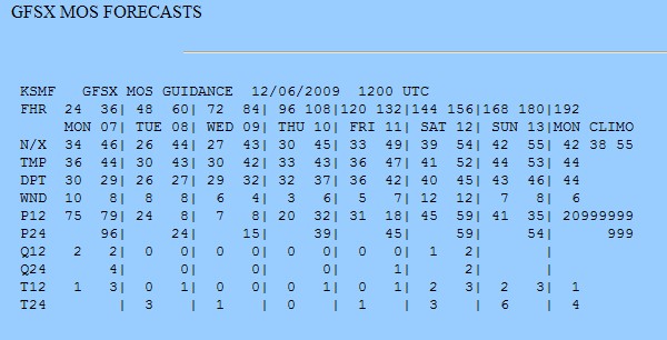
Here is the Dec. 6th (Sunday) computer model output for Sacramento. For Monday morning it indicates a minimum temperature of 34 degrees and a dewpoint
temperature of 30 degrees with a 75% probability of precipitation. This is a close call for snowfall, and at least indicates a very low snow
level. For Tuesday morning the probability of precipitation decreases to 24%. However, the minimum temperature is indicated to be 26 degrees.
This usually indicates a clearing condition, but there might still be a change of scattered showers in the area.
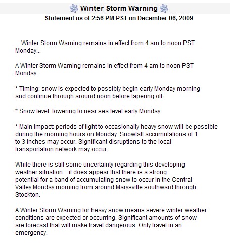
Here is the advisory from the National Weather Service as of 3pm Sunday afternoon, December 6th, 2009. I have never seen anything
like this ever before issued by the Sacramento National Weather Service office.
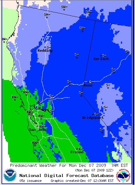
The National Weather Service Digital Forecast Database produces a product showing where there will be rain or snow. Here is the forecast
graphic for 4am Pacific Time, Monday December 7th.