|
Tom Loffman's Sacramento Weather Forecasts and Information |
|---|
|
|
Tom Loffman's Sacramento Weather Forecasts and Information |
|---|
|
North wind picking up and temperatures up a bit as well. My weather station now says 56 so warmest since last Wednesday. Morning low was still 27.5 and with current dew point at 26 we could have yet another sub-freezing morning, depending on wind speed. Where the wind is light temperatures will go sub-freezing again. If the wind can stay up a bit we may escape the deep freeze. Cat water dish had ice on it again this morning and they are getting tired of this as well.
Since the Arctic Cold of January, 2007 is modifying this will be the last update of this weather event on this page.
Update: Wednesday morning, January 17, 2007 Weak weather system came through last night and a few showers fell in our area, with rain in parts of the Bay Area. System is now a swirl of clouds near Santa Barbara. The system did produce enough cloud cover to keep minimum temperatures in the upper 20's and low 30's. The "official" Sacramento stations stayed just above freezing. However, my weather station recorded a low of 27.5 with a dew point of 17 at 7:52am, so the Arctic air, in modified form, is still hanging around. As I write this (11am) the weather station says it's 38 degrees with a dew point temperature of 26. Well, 26 is up a bit from the past few days, but it's still sub-freezing. Now that skies have cleared and the wind is light we should continue to have cold nights. The computer models say that the string of freezing nights is over. However, if the dew point continues to be below freezing and the skies are clear, and the wind is light there will be little to prevent the nights from dipping into the 20's again away from the warmer urban areas. I am not going to uncover my pipes and plants until I see the dew point at my weather station above 32, and I would urge caution for all in this regard. Long range computer models lock the upper level ridge over the West Coast through the end of the month. This will prevent storms from reaching us. The models have been trying to break down the ridge and bring in some precipitation during the last week of the month, and this morning they continue this trend. However, the models have been having difficulty with the patterns across the Pacific, so confidence in the long range is low. Still, we might get some moisture breaking through the ridge in the last few days of this month, but it wouldn't surprise me if it didn't happen. Bottom line, much drier than normal the remainder of the month, with night temperatures below normal.
Update: January 16, 2007, early evening Skies are partly cloudy and we would expect temperatures to be higher than last night at the same hour. However, for most locations they are just as chilly. Now, a very weak weather front is headed our way accompanied by some light shower activity, followed by the upper level portion which will also contain a few scattered showers. It's still possible to have some sort of frozen precipitation from this system in the valley. There might be some freezing rain and some snowflakes may fall in isolated locations - particularly over the higher elevations of the Coast Range and the hills around the Bay Area. Beyond this system there is controversy about when the 20's will come to an end at night. Most of the computer models raise the lows into the 30's for some locations. However, the computer models did the same back in 1990 and the temperatues refused to climb. Why? Because the air remained very dry with low dew point temperatures and that allowed the heat to escape into space at night. In order for the night temperatures to climb out of the 20's we need either cloud cover, or a warmer airmass to dislodge this modified Arctic air. Until that happens we could continue to experience lows below freezing. Looking farther out, still no major storms on the ultra long range maps for us. The models have been trying to break down our huge upper air high pressure ridge and bring in precipitation starting around January 21. However, recent computer models runs indicate that the high (ridge) will hold off the Pacific storms and any significant precipitation, at least until early February.
Update: January 16, 2007, morning Computer models consistent bringing in some chance of precipitation late tonight and early Wednesday. POPs about 40% with temperatures at or below freezing. This is going to be interesting. If precipitation does occur it could be in the form of snow to very low elevations, or even the valley floor. Will it snow? Actually, will any precipitation fall at all? Since this is a weak system, and the airmass over us is very dry nothing would surprise me. Yes, there is a chance of snow. Since this system will be stronger farther to the west there is actually a better chance of snow in the Bay Area, particularly over the hills. It is common in these situations for the Oakland hills to get snow. Current satellite photos clearly show the front moving our way. Currently raining at Crescent City with a temperature of 39 degrees. Look for precipitation with a dew point near freezing. Generally, it can snow at temperatures in the mid 30's, but the dew point has to be 33 or lower. After this minor front passes we will continue to have cold overnight low temperatures. The computer models indicate some raising of the low temps, but they did this back in 1990 and the nights stayed cold. What must happen for the lows to dig out of the deep freeze is the dew point temperature must rise, the cloud cover must increase, the wind must pick up from the west or southwest - in other words, something significant must blast the Arctic air out of here. And, until that happens, continue to watch for the cold nights.
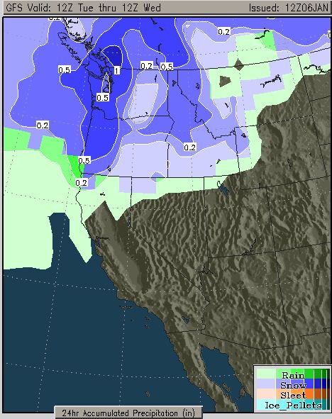
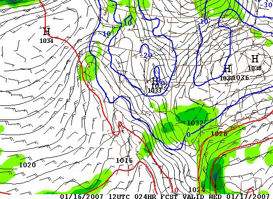 Here is the forecast map for 4am Wednesday morning. Notice the area of green over Central California representing forecast precipitation. Notice also the blue line. This is the forecast 32 degree line. Any green inside (to the east of) the blue line would represent snow. It's very close. Also notice that most of the precipitation is west of Sacramento and centered more over the Bay Area.
Update: January 15, 2007, evening Sharp cold again tonight. Readings from official stations in many locations are in the upper 20's and temperatures have been hitting their lows at 7:30 to 8:00am - so we have a long and cold night ahead of us. Meanwhile, the forecast situation is becoming more and more interesting with each computer model run. As I have been discussing here for some time, the models have been forecasting a chance of showers for Tuesday night and Wednesday morning for our area. However, the models have been saying that most of the moisture, and possibly all of the moisture, if any, would stay offshore, or just hit the coast. But now, the models are consistently moving the moisture a bit to the east, and that means a definite chance of showers for the Sacramento region from this system. Given that the forecast temperatures tomorrow night and early Wednesday should be near or below freezing, if any precipitation falls it might be, and probably will be in the form of light snow. As always, moisture in these situations is limited in the cold and dry air. So, it might snow, and it might miss. This evening the models have upped the POPs - Probability of Precipitation - to between 56-63% over the area, with forecast low temperatures between 29-33 degrees. I can't recall seeing that high a POP with that low a temperature forecast in several decades. On the satellite photo (above) you can see a narrow front moving toward us. Behind it there is a small upper-level low that was forecast to move offshore, but now is forecast to combine with the front and move more directly over us. It is a very weak area of low pressure, and the moisture in it, and the front, is very limited, so at this time I'm not making much of the chance of precipitation. Tomorrow mornings computer runs will be very interesting. By the way, it doesn't have to be 32 degrees to snow if the dew point is low enough. In dry air, the wet bulb temperature on the surface of a snowflake will keep its surface cold enough so that it won't melt, and the flake will reach the ground despite an actual temperature well into the mid, and often upper 30's. We definitely have low dew point air locked into the valley, but of course, that might also evaporate any snowflakes before they reach the ground. Current dew point at my weather station is 17.
Update: January 15, 2007, afternoon Temperatures will fall rapidly tonight and end up near where they were this morning. Wind has died down to almost nothing in most areas so the cold layer will build up and lock in at ground level. Dew point temperatures continue to be low - currently at my weather station 20 degrees. Tomorrow night and Wednesday morning forecast still problematic. Some moisture indicated on some of the computer models for a chance of precipitation and very cold temperatures. Will wait for the 00z (4pm) model run before offering any more ideas. Might be interesting, might be nothing.
Update: January 15, 2007, morning Lows again down into the 22-24 range this morning as the wind dropped off in a few areas. Some locations had the coldest morning of this cold wave. Now that we are in the Internet age, there are many home weather stations in the area taking minute by minute temperatures and feeding them into the Weatherunderground.com web site. This morning many of these stations recorded the lowest temperatures yet of this cold wave: Mather Heights School 21.8 and Sacramento Waterman/Calvine 23.0. Most other locations were within a degree of the low recorded a few days ago. Some area lows just a short time ago: Rocklin 22.8, Granite Bay 21.6, Lincoln (me) 22.6, Elk Grove 23.2, Folsom 24.2, Orangevale 22.8, Citrus Heights 23.8, College Greens 23.9 - and there are many more similar readings. Tomorrow (Tuesday) night and into Wednesday morning a small area of low pressure will drop down the coast from Alaska and bring a very slight chance of showers to Northern California - and with temperatures this cold it would mean very low elevation snow - IF the showers move inland. However, as I have been discussing here, the computer models still take this low offshore and keep our chance of any precipitation low. The coast and the Bay Area might get some showers. Since this is a close one I will continue to call for a slight chance of showers from this system. Probability of Precipitation (POPs) on this system are about 30% for Sacramento. Forecast low temperatures Wednesday morning are 29-30 degrees. It's an interesting combination. Other combinations are Napa 36% at 28 degrees, Oakland 35% at 34 degrees, Santa Rosa 39% at 30 degrees. If it does snow nearby you heard it here first.
Update: January 14, 2007, evening Computer models now in agreement. The next low pressure will stay offshore - most of it....That means, on Tuesday night and into Wednesday there is only a very slight chance of showers for our area. There is a better chance of showers along the coast and in the Bay Area. Next series of cold lows dropping down from Alaska forecast to stay inland, so the pattern of generally dry conditions with low humidity and cold mornings will continue. This Tuesday/Wednesday system might have produced some rain and or snow, but as each computer model run takes place it looks less likely that it will happen.
Update: January 14, 2007, afternoon Here are the lows from last night:
 REGIONAL TEMPERATURE AND PRECIPITATION SUMMARY...UPDATED DTS HIGH
 NATIONAL WEATHER SERVICE SACRAMENTO CA
 450 PM PST SUN JAN 14 2007
 :
 :OBSERVATIONS TAKEN AT 400 PM...TEMPERATURE...PRECIPITATION...INCHES
 .B STO 0114 P DH16/TX/TN/PP/SD
 :
 :HIGH TEMPERATURES ARE FOR TODAY
 :LOW TEMPERATURES ARE FOR TODAY
 :      ...NORTHERN/CENTRAL SACRAMENTO VALLEY AND FOOTHILLS...
 SHDC1:      SHASTA DAM        1075 :    M /  31 /     M /
 RDD  :      REDDING AP         502 :   53 /  19 /  0.00 /
 RBL  :      RED BLUFF          349 :   53 /  20 /  0.00 /
 WLSC1:      WILLOWS 6W         233 :    M /   M /     M /
 CIC  :      CHICO              238 :   53 /  22 /  0.00 /
 OVE  :      OROVILLE           192 :   52 /  25 /  0.00 /
 PDEC1:      PARADISE          1750 :   50 /  27 /  0.00 /
 MYV  :      MARYSVILLE          62 :   52 /  21 /  0.00 /
 ECKC1:      ALDER SPRINGS     4500 :   40 /  25 /  0.00 /
 :
        ...SOUTHERN SACRAMENTO VALLEY/LAKE COUNTY...
 KELC1:      KONOCTI           2163 :   46 /  30 /  0.00 /
 DTS  :      SACRAMENTO          25 :   50 /  26 /  0.00 /
 SAC  :      SACRAMENTO EXEC AP  21 :   49 /  22 /  0.00 /
 SMF  :      SACRAMENTO INTL AP  25 :   51 /  22 /  0.00 /
 VCB  :      VACAVILLE          113 :   53 /  20 /  0.00 /
 WDLC1:      WOODLAND            69 :    M /   M /     M /
 :
 :      ...DELTA/NORTHERN SAN JOAQUIN VALLEY...
 SUU  :      TRAVIS AFB          40 :   49 /  19 /  0.00 /
 SCK  :      STOCKTON AP         29 :   49 /  24 /  0.00 /
 MOD  :      MODESTO AP          97 :   48 /  23 /  0.00 /
 :
 :      ...MOTHERLODE...
 GRAC1:      GRASS VALLEY      2500 :    M /  18 /     M /
 AUBC1:      AUBURN            1360 :    M /   M /     M /
 SRLC1:      SUTTER HILL       1300 :    M /  24 /     M /
 ADSC1:      SAN ANDREAS       1100 :    M /   M /     M /
 SONC1:      SONORA            1750 :    M /  15 /     M /
 GROC1:      GROVELAND         2850 :    M /  10
Arctic airmass is modifying - dew points up a bit (now 19 on my weather station). North wind was with us today so it felt colder because
of the wind chill. Another sub-freezing night tonight, but with higher dew point temperatures and a bit of north wind I would expect
lows will not be as severe.Computer models continue in confusion about upcoming chance of precipitation. Timing is consistent - Tuesday night into Wednesday, but some models take the low too far offshore for any precipitation here. After that, another chilly low moves down over us around the 22nd, and again on the 26th. These are all systems from the north and all with little or no moisture present.
Update: January 14, 2007, morning Very cold again last night with upper teens and lows 20's common. Dew point temperatures increasing slightly so the Arctic airmass is modifying a bit - likely just some moisture evaporating into the air from our rivers, lakes and Delta. Low temperature at my weather station up four degrees from Saturday morning. It was colder than Saturday earlier in the evening, but temp stopped falling during the night. North wind picking up slightly today so we should feel a bit of a wind chill - not as bad as on Friday. Morning computer model runs continue to bring in a chance of showers Tuesday night and into early Wednesday, but probability of precipitation has lowered. When this disturbance first showed up on the models it was forecast to stay offshore. Then the models brought it over us. This morning, the models want to keep it mostly offshore again. Currently only a slight chance of showers when this small low moves through. Temperatures will be near freezing at the time so IF there is any precipitation it should fall as snow to very low elevations - possibly sea-level. We've been through this before, so not making anything of this at this time. Current National Weather Service forecast also calling for a slight chance of showers Tuesday night and Wednesday. Notice that the low temperature forecast for Wednesday morning is for low 30's which would bring the snow level to near the valley floor. Again, limited moisture and timing is the forecast problem.
.TUESDAY NIGHT...MOSTLY CLOUDY WITH A SLIGHT CHANCE OF LIGHT RAIN SHOWERS. LOWS AROUND 33.
.WEDNESDAY...MOSTLY CLOUDY WITH A SLIGHT CHANCE OF LIGHT RAIN  SHOWERS. HIGHS AROUND 50
After this small low moves through the long range maps continue to bring in other disturbances from the north or northeast - all of them cold, and all with limited moisture. For a couple of weeks the models have been indicating a chance of showers here during the January 21-24 time period and they continue to do so, although the amounts of precipitation appear to be low. The 22nd now appears to be a date when we might expect some rainfall with snow to lower elevations. The models have not had a consistent grip on the pattern changes across the Pacific so confidence in the forecast is low - particularly as we move out beyond the next few days.
Update: January 13, 2007, evening Colder in all valley locations by several to as many as 11 degrees compared with same hour last night because wind is down. Expecting the wind to continue to be light all night so morning lows will be in the upper teens to low 20's in most locations. Dew point temperatures still very low - as I write this my weather station says 10 degrees dew point, so the Arctic air is firmly in place. These cold mornings will continue until there is a dramatic change in the pattern and the ultra dry air is replaced by moister air. Speaking of moister air, the computer models continue to forecast another week low pressure area to move down from Alaska next week and bring a chance of showers to our area starting Tuesday evening into Wednesday. Even though this system is not as cold as the last one, we still have Arctic air in place, so temperatures will be cold when the moisture arrives, so we should have very low snow levels. Not all of the computer models agree that the precipitation will reach us, so the situation only calls for a chance of chilly showers. Best timing for this would be Tuesday night and into Wednesday morning. Latest POPs (Probability of Precipitation) for Sacramento for Wednesday morning is 45% and forecast low temperature is 32 to 34 around the area. Perhaps the snow that we didn't get (too dry) when the Arctic air arrived may develop after all IF this new system arrives.
Update: January 13, 2007, late afternoon Very weak trough moving through NW California now with a few clouds showing up in our area. No precipitation. No change in thinking based on latest computer model run. Still possible to get some chilly showers late Tuesday evening and Wednesday. National Weather Service is adding them to its forecast for Wednesday. No discussion of expected snow level, but it will be low.
Update: January 13, 2007, afternoon Everything in place for another very cold night. Currently my weather station is reporting a high of 48 with a dew point temperature of 8. The wind remains very light, so the freeze tonight will arrive quickly and hit hard. Low 20's should be more widespread than yesterday morning because the wind will be lighter over the entire area. Computer models continue to indicate a small upper air disturbance with precipitation moving into Northern California on Tuesday evening and Wednesday morning. The arctic air will be still with us at that time, although it won't be quite as cold. The different computer models are not yet in any agreement on the position and strength of the disturbance so confidence in any forecast is low. However, adding rainfall to this type of airmass would result in very low snow levels. It's worth watching.
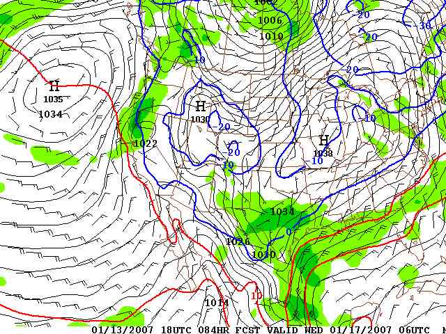 Forecast map for Tuesday evening at 10pm. The green areas indicate precipitation. The blue line over Sacramento is the 0c or 32f line. The computer models have not had a consistent grip on this pattern, but they all do bring in something along the West Coast at that time. I will continue to monitor the progress of this here.
Update: January 13, 2007, noon Lows are in for this morning. Some highlights (lowlights actually) include Chico 20, Executive AP 22, International AP 21, Fairfield Travis 17, and Stockton 20. The Sacramento National Weather Service reported 27. There was still some wind last night so temperatures were still up a bit from what they might have been if the wind had been calm. It will be nearly calm tonight, so even lower lows are possible in a few areas.
 :      ...NORTHERN/CENTRAL SACRAMENTO VALLEY AND FOOTHILLS...
 SHDC1:      SHASTA DAM        1075 :   44 /  31 /  0.00 /
 RDD  :      REDDING AP         502 :   45 /  25 /  0.00 /
 RBL  :      RED BLUFF          349 :   45 /  27 /  0.00 /
 WLSC1:      WILLOWS 6W         233 :    M /   M /     M /
 CIC  :      CHICO              238 :   45 /  20 /  0.00 /
 OVE  :      OROVILLE           192 :   45 /  27 /  0.00 /
 PDEC1:      PARADISE          1750 :   41 /  26 /  0.00 /
 MYV  :      MARYSVILLE          62 :   45 /  24 /  0.00 /
 ECKC1:      ALDER SPRINGS     4500 :   32 /  22 /  0.00 /
 :
        ...SOUTHERN SACRAMENTO VALLEY/LAKE COUNTY...
 KELC1:      KONOCTI           2163 :   38 /  29 /  0.00 /
 DTS  :      SACRAMENTO          25 :   47 /  27 /  0.00 /
 SAC  :      SACRAMENTO EXEC AP  21 :   46 /  22 /  0.00 /
 SMF  :      SACRAMENTO INTL AP  25 :   46 /  21 /  0.00 /
 VCB  :      VACAVILLE          113 :   46 /  30 /  0.00 /
 WDLC1:      WOODLAND            69 :    M /   M /     M /
 :
 :      ...DELTA/NORTHERN SAN JOAQUIN VALLEY...
 SUU  :      TRAVIS AFB          40 :   45 /  17 /  0.00 /
 SCK  :      STOCKTON AP         29 :   49 /  20 /  0.00 /
 MOD  :      MODESTO AP          97 :   51 /  26 /  0.00 /
 :
 :      ...MOTHERLODE...
 GRAC1:      GRASS VALLEY      2500 :   38 /  18 /  0.00 /
 AUBC1:      AUBURN            1360 :   45 /  24 /  0.00 /
 SRLC1:      SUTTER HILL       1300 :   43 /  24 /  0.00 /
 ADSC1:      SAN ANDREAS       1100 :    M /   M /     M /
 SONC1:      SONORA            1750 :   44 /  16 /  0.00 /
 GROC1:      GROVELAND         2850 :   37 /   9 /  0.00 /
Update: January 13, 2007, 8am
.jpg)
.jpg) Photo of my weather station this morning at 8:15 - temperature at 21.7 and dew point at 2! Next photo is the fountain in the courtyard in front of my house nicely iced up. Deep freeze in place this morning over Northern California. Official lows not in yet, but so far Stockton has hit 20, Fairfield 21, International Airport 24, Truckee -8, Tahoe Valley -5, and at my weather station in Lincoln 21.5 at 8:02am. There is still a breeze in some locations keeping temperatures up a bit. With less breeze today it should feel less cold during the afternoon. Tomorrow morning another cold one - most wind gone, so the cold air will really have a chance of locking in over the area. For a number of days the long range weather maps have been bringing in a small storm for the middle of this coming week - Wednesday. The low has been forecast to drop down the coast and the rainfall has been kept near the coast. On this mornings maps there are indications that the low may be closer to the coast so I'll mention a chance of chilly showers on Wednesday and perhaps Thursday. If it does rain, it will be a low snow level event since this arctic air will still be hanging around - at least in some form. There is yet another small front indicated to move in on Sunday - again coming in from the north. The following week - starting January 21st, might also have rainfall as the long range maps continue to bring in a storm in that time period.
Update: January 12, 2007, evening Wind has died down and it's going to be a very cold night. Prepare for low to mid 20's, and if you are in a rural, wind protected area, particulary a low spot, it might drop to the upper teens. Last night temperatures fell to 26 in Marysville and 28 at Executive and International Airports. It will be colder tonight.
Update: January 12, 2007, late morning Latest computer forecasts for low temperatures over the next couple of days (after the wind dies down) have been revised lower. In particular, the San Joaquin valley may dip into the upper teens. Before this cold event is over we may fall to levels of cold not seen since December, 1990. Expect overnight lows to drop 10 degrees lower than last night. The north wind is still the major factor - keep the wind up at night and the low temperature will be up a bit, but let the wind die down and the cold will lock in. Why is this? Because at night the ground cools off first forming a shallow layer of very cold air that builds as the night progresses. When the wind blows this shallow layer of cold mixes with warmer air above and so temperatures at person level, where we measure the official lows and highs, are warmer than they would be otherwise. Here are some forecast lows off the latest computer model run for the next few nights: Beale AFB 26, Livermore 20, Marysville 21, Mather 20, Modesto 20, Napa 19, Oroville 23, Executive AP 22, International AP 21, Stockton 17, Fairfield 25, Vacaville 23. Update: January 12, 2007, morning North wind kept minimum temperatures up last night - as much as five degrees warmer than might have occurred otherwise. My low here in Lincoln dropped to 30.7 at 12:22am. Never got below that because of the wind. The humidity is rock bottom. My dew point temperature dropped to 8 at 8:07am. Over the next couple of days the wind will die down and it will feel a bit more comfortable. However this will let the overnight cold settle in and most areas will drop into the low to mid-20's, and some wind protected spots may get into the upper teens.
Update: January 11, 2007, late evening The north wind is blowing again, and that is actually keeping the temperature up in many locations - a very good thing for plants and pipes since it may keep morning lows from hitting the 20's in some locations. However, the wind is creating a very cold wind chill effect, so it will feel much colder. The north wind can raise overnight temperatures as much as 20 degrees - hard to believe, but true. As I write this it's 24 in Hanford (near Fresno) with no wind, and 41 in Vacaville with a north wind of 17 mph. It's 31 at Executive Airport with a north wind of 14, but a wind chill of 21. The chance of showers is basically over. There was a trough of low pressure that brought rain and snow to the North Coast this afternoon, but as it moved to the south it weakened and kept offshore, so it looks like this will be an entirely dry weather event.
Update: January 11, 2007, evening It's getting very cold and the night is still young. The area of showery weather (rain and snow to sea-level) that has been moving southeast from the North Coast of the state is weakening rapidly. Satellite photos (see above) show very little, if any moisture left in this small area of low pressure, so the chance of any showers in the valley is almost gone despite official probabilities of precipitation (POPS) still at 10%. All precautions to prevent pipes from freezing should be taken immediately. Frost sensitive plants must be covered or taken inside. Please provide some way for your outside pets to have shelter.
Update: January 11, 2007, afternoon Snow is now falling at Crescent City with a temperature of 34 degrees. The dew point temperature there is 33 degrees. It's also snowing at the Tahoe Valley airport. A trough that is producing the North Coast snow is moving in our direction. It can be easily seen on the satellite photos at the top of this page - the visible and IR. When it arrives later this evening there should be some increase in cloudiness and there is always the possibility of scattered showers in the valley. However, our humidity is now very low - current dew point temperature at my location is 15 degrees and relative humidity is 26%. Even if showers fall from the clouds the moisture may evaporate before reaching the ground. Once this trough passes it will be bone dry with very cold morning temperatures. Expect five morning lows in the 20's for most valley locations. A few spots may go into the teens. There is and will continue to be some wind, so wind chill values will be very uncomfortable - dress in layers.
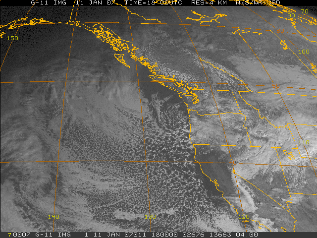
Update: January 11, 2007, early afternoon Satellite (see above) photos continue to show a trough of low pressure now over southwestern Oregon and northwestern California moving in our direction. It's possible that when it arrives we could get some scattered showers out of it, however, the airmass is now very dry over Norther California and the chance of showers remains very slim. At my home here in Lincoln the current temperature is now 50 degrees and the dew point temperature continues to plummet - now at 14 degrees F. This is a sign that the arctic airmass is slowly moving over us. I will continue to monitor the trough as it moves toward the southeast.
Update: January 11, 2007, late morning The swirl of clouds and showers over western Oregon is moving slowly southward. When it reaches Northern California is may produce showers that would fall as snow to sea-level if enough moisture is left as the showers fall into very dry air now in place over the area. This swirl of clouds appears to be developing into a small area of low pressure (vorticity center). To see the latest visible satellite animation click on the following:
Update: January 11, 2007, morning Arctic air is now moving over Northern California. Low temperatures this morning ranged from the upper 20's to the mid-30's around Sacramento. My low temperature in Lincoln was 32.7 at 8:13am. Dew points have fallen as the arctic air moving in is very dry. My dew point temperature reached 20 degrees this morning. It had been in the low 40's yesterday afternoon. Showers have fallen in the Sierra, but moisture is very limited. An area of moisture with scattered snow showers is now centered over western Oregon. As this air moves southward showers are likely to increase over Northern California later today and this evening, but the chance of snow showers in our area is slim at best. We are expecting at least five mornings with lows in the 20's. In most areas low 20's will be common. In a few areas upper teens will be recorded. Some increase in wind is expected as well so wind chill values will be low. All computer maps indicate that Las Vegas is going to get a winter blast from this pattern, as the upper level pool of cold air with moisture will be settling over that city on Friday. If you have plans to go to Las Vegas make sure to check the weather reports. Longer range computer models are having a difficult time deciding on our next storm. Every computer model run is a bit different, so nothing appears well defined past the current cold spell other than we will continue to have below normal temperatures especially at night.
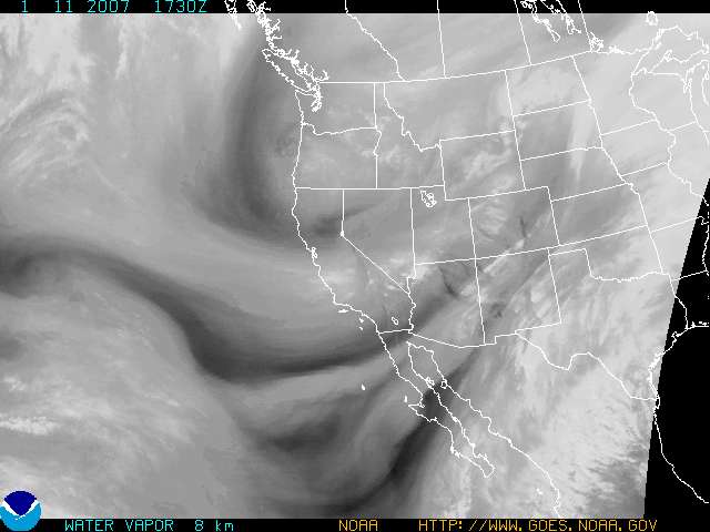 Water vapor image from this morning shows swirl over western Oregon that is currently producing scattered snow showers. As this moves southward the shower activity should increase in Northern California, but is not expected to amount to much.
 Latest visible satellite photo shows swirl of showers over western Oregon and relatively clear skies over Central California. As this counterclockwise swirl of clouds and showers moves southward both cloudiness and instability showers should increase over our area. However, the question remains: will there be enough moisture in these showers to produce snow in the valley? At this point we're not expecting much other than more cold.
Update: January 10, 2007, late evening Latest information indicates that timing of cold air intrusion into our area somewhat delayed and amount and depth of cold air may be less intense than on previous forecast maps. Amount of moisture available for showers limited. These changes are slight, so we are still getting the arctic air, and it's still going to be very cold, and there may still be some scattered showers, but the coldest air will be arriving slightly delayed, it may be a couple of degrees warmer than feared, and the chances of showers is even lower than anticipated. Best timing now for showers would be late Thursday into Friday morning. Snow showers still possible. My water pipes are covered and the delicate potted plants are in the garage. Napa is already below 32 degrees. If you're headed for Las Vegas their forecast calls for snow on Friday.
Update: January 10, 2007, evening Temperatures are falling, the wind has picked up, clouds are moving in, and the much awaited arctic cold air is on its way into Northern California. Later tonight through early Friday there will be a chance of scattered showers over the area. Since we are expecting temperatures in the mid 30's by morning (possibly lower in a few spots) there is a slight chance of snow showers as well. If enough moisture can last into Friday morning, temperatures at that time will be even colder and any showers that fall should be in the form of snow. The National Weather Service has snow in the forecast for Sacramento for Friday morning - only showers, and only a slight chance. Temperatures are still expected to drop to the low 20's in the next few days in the morning and it's still possible that upper teens may be reported from a few areas, so make preparations now. The latest computer maps indicate a slight chance of some showers by the middle of next week and a better chance in the week of January 21-26. At that time another wave of cold air should be moving over the area so things might get interesting. However, we are looking two weeks out, and have little confidence in the ultra long-range maps at that distance. Still, the computer models continue to bring in some sort of cold storm centered around that time frame, so I will keep readers up to date here. Stay warm!
Update: January 10, 2007, late afternoon Snow if falling at sea-level in Washington and Oregon as the arctic air heads south. This afternoon snow has fallen in and around Puget Sound in Washington and in Oregon it's snowing on the coast at Astoria and in Eugene. Snow has begun to fall in the Sierra with flurries starting at Tahoe. Blue Canyon has been reporting light rain at 34 degrees, but the temperature there will be falling rapidly and the rain will turn to snow shortly. As the arctic air moves over Northern California the temperature will be falling rapidly and the dew point temperature will also fall - now at 40 degrees. Rain will change over to snow at a dew point temperature of about 32 degrees and an actual temperature in the mid to upper 30's - it doesn't have to be 32 degrees to snow as long as the dew point is low enough. The temperature at Blue Canyon is 34 and the dew point is 34 - and it's raining.
Update: January 10, 2007, afternoon Cold temperatures headed for Northern California. Forecast maps all in agreement about the cold, but timing and amount of showers, if any, remains questionable. The airmass coming in is very dry and if any showers fall they will be light. If we do get any they will occur late this evening or early Thursday morning and continue into Friday morning. It is likely there will be clearing periods with only partly cloudy skies. Temperature and dew point values should be cold enough for snow to near sea-level after 10-11pm tonight, but there may not be enough moisture present to produce anything at all. Low temperatures will be with us for several days and could get down into the low 20's, with upper teens not out of the question in a few areas.
Update: January 9, 2007, evening As noted earlier, the probability of precipitation has been extended into Thursday night/Friday morning with temperaures at or below freezing at that time. This afternoon, the National Weather Service included a chance of snow showers in its official forecast for Sacramento:
SOUTHERN SACRAMENTO VALLEY- INCLUDING THE CITY OF...SACRAMENTO 340 PM PST TUE JAN 9 2007. Model run from this afternoon continues to call for very low temperatures on Saturday morning: Oroville 26, Marysville 24, Executive AP 25, International Airport 22, Mather 22, Vacaville 26, Fairfield 23, Napa 19, Livermore 21, Stockton AP 21, Modesto 23. A few of these forecast temperatures are up a degree or two from 12 hours ago, Fairfield is down 1 and four are the same. Bottom line again - very cold, with a slight chance of low elevation snow starting late Wednesday night into early Friday morning. Be prepared for upper teens to mid-20's depending on your location.
Update: January 9, 2007, mid-afternoon Here are some forecast low temperatures for various valley locations for Saturday morning. It's time to start preparing by covering your plants, pipes, and providing shelter for outdoor pets: Oroville 26, Marysville 22, Sacramento (Executive AP) 23, Sacramento (International Airport) 20, Mather 21, Vacaville 24, Fairfield 24, Napa 19, Livermore 21, Stockton AP 20, Modesto 23. I will update these forecasts as more information becomes available. The bottom line: be prepared for possible upper teens or low 20's. Better be prepared than suffer lost plants and burst pipes. Update: January 9, 2007, early afternoon Latest computer model maps indicate some changes in the forecast, but they are minor ones. The new maps indicate that the very cold coming in may be a bit colder than forecast yesterday, and the probability of any precipitation, whether rain or snow, has increased a bit. As an example, yesterday afternoon the model output statistics (GFSX MOS) for Marysville said 36 degrees and 40% chance of precipitation for Thursday morning, 29 degrees and 30% for Friday morning and 25 degrees and 2% for Saturday morning. This morning the 12z (4am) model run says 33 degrees and 53% for Thursday morning (down 3 degrees and up 13%), and for Friday morning 27 degrees (down 2) and 20% chance (down 10%) and for Saturday morning 22 degrees (down 3) and 3%). For Sacramento (SMF) the forecast numbers from yesterday indicated the coldest morning would be Saturday with 24 and the highers probability of precipitation would be Thursday morning at 36%. This morning's run shows 20 degrees for Saturday morning and 48% for Thursday morning. The reason for these changes is that the models are indicating a stronger push of arctic air into our region that should last a bit longer. The bottom line is that this is primarily a cold event with a slight chance of some precipitation, which could fall as snow to the valley floor IF the timing is right - that is, if the precipitation falls after the temperatures are below about 35 degrees, so the most likely time of any snow would be overnight and into the early morning hours. Temperatures should begin to fall tomorrow afternoon after the front arrives. The front should be relatively dry with just some cloudiness, but it is possible that some showers may fall tomorrow. Tomorrow night and early Thursday will continue to feel the chill settle in, and as the numbers indicate, the greatest chance for showers would be late Wednesday night and early Thursday, although the showers might continue into early Friday. Latest statement from the National Weather Service regarding possibility of snow: BELIEVE BEST BET IS TO GO WITH SLIGHT CHANCE POPS OVER CWA WITH A LITTLE HIGHER POPS OVER HIGHER ELEVATIONS. ALTHOUGH PRECIP THREAT THURSDAY AND THURSDAY NIGHTS IS LOW...BIG QUESTION IS WHETHER ANY PRECIP THAT MIGHT FALL COULD FALL AS SNOW ON THE CENTRAL VALLEY FLOOR. LATEST BUFKIT DATA WOULD INDICATE THAT ALTHOUGH IT WILL BE CLOSE...SNOW LEVELS WILL BE ABOVE THE VALLEY FLOOR THROUGH PRECIP THREAT PERIOD OF FRIDAY MORNING. HAVE THEREFORE LEFT MENTION OF SNOW OUT OF VALLEY FORECASTS EXCEPT REDDING AREA WHICH HAS SOME HIGHER ELEVATIONS. STILL...SNOW LEVELS WILL BE QUITE LOW AND ANY PRECIP WOULD LIKELY FALL AS SNOW IN THE FOOTHILLS.
Update: January 8, 2007, evening Finally, some minor, but interesting changes in the computer forecast numbers for Thursday and Friday. These changes increase the chance of precipitation during this very cold air intrusion into our area. For Sacramento International Airport (SMF) the POP (Probability of Precipitation) numbers generated yesterday for Thursday morning were 29%, for Thursday afternoon 23% and for Friday morning 16%. Now, they are 36%, 32% and 32%. On Thursday morning the low is forecast to be 36 and Friday morning 30. This increases the chance that we may see some snow showers in the valley after all. The National Weather Service says this in its evening discussion: IT APPEARS THIS TROUGH WILL TRACK MORE OVER LAND...WITH PRECIPITABLE WATER VALUES ONLY NEAR A QUARTER OF AN INCH. IN COMPARING THESE PW VALUES TO THE MARCH 12TH 2006 AND THE JANUARY 28 2002 SNOWFALLS IN SACRAMENTO...THESE PWS VALUES ARE A LITTLE LOWER THAN THESE EVENTS. HOWEVER...THE 850 AND 700 MILLIBAR TEMPERATURES LOOK TO BE COLDER. THEREFORE...WILL INCLUDE A MENTION OF SNOW FLURRIES IN THE CENTRAL AND SOUTHERN SACRAMENTO VALLEY AT THIS TIME...BUT DO NOT EXPECT THE SNOW TO STICK IF IT OCCURS AT ALL.
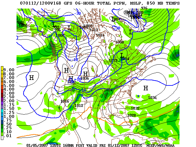
 This is the 700mb (10,000ft level) forecast chart for Thursday evening at 10pm. The green areas indicate higher concentrations of moisture at upper levels, and show likely areas of rainfall. Notice that right over Sacramento there is a slightly darker green area. This wasn't there before and indicates a trend toward a slightly higher chance of showers over us at that time.
Update: January 8, 2007, afternoon Temperatures will begin to fall on Wednesday as the very cold front approaches, and there is a chance of chilly showers Wednesday night through Thursday. Thursday morning temperatures should dip to the mid-30's around Sacramento, and the probability of precipitation will be 20-35% depending on location. We may not get any rain or snow, but it's very unusual to have this combination of low temperature and some precipitation. Could we get snowflakes in the valley? Yes. Is it likely? Probably not, but you never know. The main feature of this new weather pattern will be the cold that will be coming in. Expect low temperatures in the mid-20's with some locations even colder, depending on location and wind. Also there will be low humidity and some very uncomfortable wind chill. The next storm pattern, mentioned on an earlier update, continues to show up on the 16 day forecast maps - cold and very wet. However, that far out we have very low confidence of the event actually occurring. Still, I will continue to monitor it here. Update: January 8, 2007, early morning Forecast remains the same - very cold temperatures moving in but moisture limited, so chance of showers for our area late Wednesday through Thursday also limited. Snow over higher elevations and foothills likely. On the ultra long-range models a similar pattern is setting up for January 24th with more overwater trajectory. However, the models have only marginal forecasting skill that many days ahead. Still, looks like a very interesting pattern and worth tracking here as the days progress. Bundle up! This is going to be a very cold month.
Update: January 7, 2007, early evening No change in forecast pattern - turning colder mid-week and very cold by Thursday through the weekend. Late Wednesday evening and then into early Friday some moisture is indicated along with the cold air moving in for a chance of scattered, light showers over the area. Temperatures will be cold enough for snow to sea-level if the moisture arrives during the time of minimum temperature - late night and early morning. However, as I have noted in these updates, this will be primarily a cold event, and any precipitation that might fall will be very light. Canadian forecast model (GEM) is now backing off on their forecast of significant moisture with this system. Another American computer model (NAM) indicates that the system may be slightly stronger than indicated on the models that I have been looking at for most of this analysis (GFS and MRF). The NAM is a higher resolution model than the GFS or MRF, however, it only goes out 84 hours and is not yet available for Thursday.
Update: January 7, 2007, morning Latest computer model run continues to show a period of very cold air moving in mid-week with a chance of showers on Thursday, possibly lasting into early Friday. The center of the upper-level low (at 10,000ft level) will be well east of our area, so the amount of moisture available to produce precipitation will be limited. There is still a possibility of low-level snow if enough moisture is present at the right time. We are now close enough to the event that we are getting some actual forecast numbers and probabilities. These numbers are from the Global Forecast System Model Output Statistics (GFSX MOS) Guidance. On Thursday morning the low for Marysville is 36 and probability of precipitation is 35%, and on Friday morning 30 degrees with 23%. For Sacramento International Thursday 36 low, 32% probability, and for Friday morning 29 low and 24%. Highest probabilities for precipitation are Thursday morning. Saturday morning should be particularly cold with minimum temperatures into the mid-20's in many locations and some temperatures colder, depending on the wind. Humidity will be very low. Dew Point temperatures should be in the teens or lower. There will also be some wind, so the weather will feel colder than the thermometer indicates.
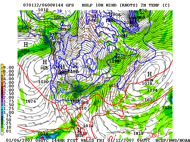
Update: January 6, 2007, evening Afternoon computer model run consistent with earlier runs and forecast calls for very cold temperatures sweeping over the region late Wednesday and continuing for a week. There is a chance of some light precipitation on Thursday the 11th and and temperatures will be cold enough for sea-level snow - but moisture will be limited. However, the Canadian computer model (GEM) continues to differ from the American models and calls for a very different scenario. On the Canadian model the cold upper level flow drops down the Pacific Coast and settles over California. This brings in considerable precipitation. In contrast, the American models have the cold upper level flow a bit to our east - too far east to pick up moisture off the Pacific. Below is a look at the evening run of the Canadian model for 4am Friday morning. Note that on the left panel there is an upper-level low parked over our area ,and on the right panel considerable precipitation indicated. If the Canadian model is anywhere near correct we could be in for a lot more than a few chilly sprinkles.
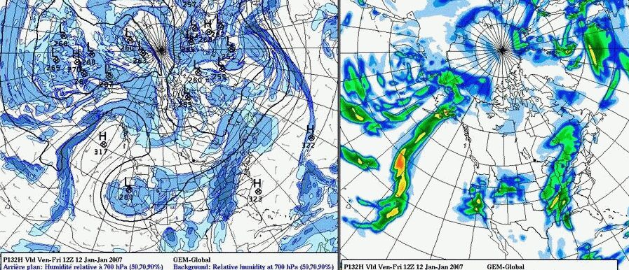 Left panel shows Canadian GEM model for 4am Friday morning (Jan. 12th). Notice the impressive 700mb (10,000ft level) low over Northern California, and on the right panel moderate precipitation covering the entire state. This solution differs considerably from the American computer models which have the low far to the east of California and moisture severly limited.
Update: January 6, 2007, mid-day Morning computer model update continues to call for cold temperatures arriving on Thursday the 11th with a slight amount of moisture during the frontal passage. Some precipitation is likely over Northern California at that time, but will it be cold enough and at the same time moist enough for snow? Right now we can't say. The new weather maps add a second shot of moisture on Saturday and call for another low to move down the coast the following Wednesday. The computer models have been calling for this Wednesday rain off and on, and this morning it's on again. At this point the only thing we're certain about is that we'll be having some very cold weather starting Thursday.
 Here is an interesting map product showing expected precipitation - amounts and type. This is for the 24hr period ending 4am Wednesday morning. Notice that the blue areas show snow in the Pacific Northwest all the way down the coast of Oregon, almost to the California border. The map is a forecast of precipitation amounts in inches. Notice that in parts of Washington over .5" of precipitation is plotted. This would be over 5" of snow since 1" of rain, on the average, translates into about 10" of snow. This map product is not available out to four days in the future and is only generated once a day. Tomorrow I'll update it here. It will be interesting to see what it forecasts for our area.
Update: January 6, 2007, early morning Overnight forecast maps show minor changes, but overall forecast remains the same. Very cold air will be moving over our area on Thursday January 11th and remain for several days. However, there will be very little moisture available from the Pacific with the frontal passage and the possibility of any precipitation here at that time, either rain or snow, appears to be slim. Still, with temperatures as cold as forecast, any precipitation that falls could be in the form of snow to near sea-level. For those of you who want even more information and speculation, AccuWeather has been discussing this potential storm and the blog can be found at: http://wwwa.accuweather.com/news-blogs.asp?partner=accuweather&blog=yeager
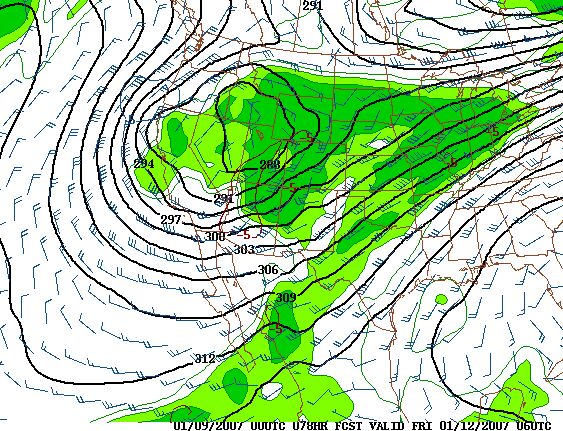
 Forecast map for Thursday January 11th at 10pm. The 10 meter (6ft above ground) temperature is indicated with blue lines. Note that the 0c line (32f line) is right over Sacramento. The green areas indicate precipitation. At 32f any precipitation would be in the form of snow. There are two small areas of green near Sacramento indicating the possibility of snow at that time, but amounts are very light, if any.
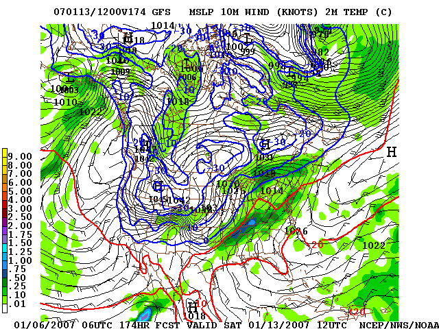 Forecast map for Saturday morning the 13th at 4am (12z). Temperatures at 2 meters (6 ft) above ground are shown in blue. Note that the -10c line is over Sacramento. This is 23 degrees F. Green areas are precipitation and the map indicates that all rain and or snow will be out of the area - it will just be very cold.
Update: January 5, 2007, evening Latest forecast maps continue to call for a wave of cold air to sweep over the area beginning late Wednesday or Thursday of next week. Some moisture is indicated during the initial cold frontal passage on Thursday, so, it is possible that snow may fall to low elevations at that time. After Thursday the moisture is limited, but the cold air will settle in over the area and persist for a number of days. Despite the fact that the long range maps are showing differences run to run, they all agree that cold air will be paying us a visit late next week and there will be some precipitation to contend with.
Update: January 5, 2007, late morning Computer model runs consistently bring in very cold air into Sacramento region with some moisture beginning next Thursday (January 11) and Friday. A second wave of cold air moves down the coast the following Wednesday, although this second wave is not as cold as the first one. There is no doubt that we will have a week of very cold weather, however, there is still a question remaining - will there be enough moisture to produce snow in the valley?
850mb (5000ft level) map for Friday morning, January 12 continues to show very cold air over Northern California with -8c to -9c indicated over Sacramento. This would be 32f at the surface. Some precipitation is indicated (green areas) but amounts are very light and widely scattered. At this temperature snow would fall to sea-level, particularly since this map shows the weather at 4am. Looking back at the same map 24 hours ago (down this page) note that yesterday the temperature indicated over Sacramento was -10c (minus 10 celsius) and there was ample moisture available for precipitation. Also note that yesterday the -30c line was indicated over the US/Canada border north of Idaho, but today that temperature is only -20c, so there will be less cold air moving south than forecast previously.
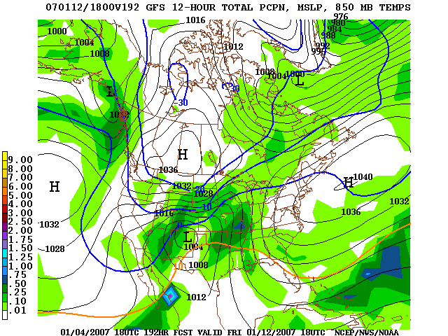
Global Forecast System map from 18z (11am) January 4, 2007 for Friday, January 12 at 11am. Green areas indicate precipitation. Notice
temperature contour lines in blue. This map is for the 850mb, or approximately 5,000ft elevation level. Temperatures are indicated to be
-8c over Sacramento at map level, or near 32 degrees F at the surface. However, on this new map the rainfall has been moved to the east
and the coldest air over Western Canada is not as far south as on the previous set of maps. Even though the general pattern remains the
same small shifts in the forecast position of the cold air make significant differences in the possibility of snow.
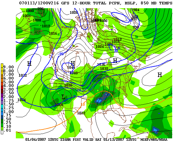 Global Forecast System map from 12z (4am) January 4, 2007 for Saturday, January 13 at 4am. Green areas indicate precipitation. Notice temperature contour lines in blue. This map is for the 850mb, or approximately 5,000ft elevation level. The -10c line is just north of Sacramento. -10c is -18 degrees F below freezing, or 14 degrees F at the 5,000ft level. During precipitation events the temperatures fall approximately 3 degrees F per 1000ft of elevation gain. So, if the temperature at 5,000ft is 14 degrees F, the temperature at sea-level would be 29 degrees F - certainly cold enough for snow in the valley. Note that the coldest air (-30) is located just over the US/Canada border north of Idaho. |
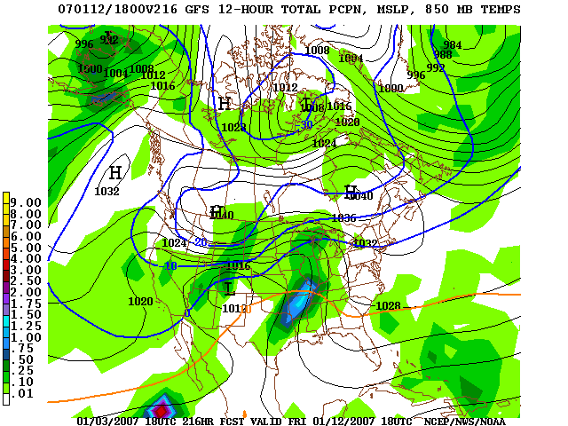
Global Forecast System map from 18z (11am) January 3, 2007 for Friday, January 12 at 11am. Green areas indicate precipitation. Notice temperature contour lines in blue. This map is for the 850mb, or approximately 5,000ft elevation level. The -10c line is just north of Sacramento. -10c is -18 degrees F below freezing, or 14 degrees F at the 5,000ft level. During precipitation events the temperatures fall approximately 3 degrees F per 1000ft of elevation gain. So, if the temperature at 5,000ft is 14 degrees F, the temperature at sea-level would be 29 degrees F - certainly cold enough for snow in the valley.